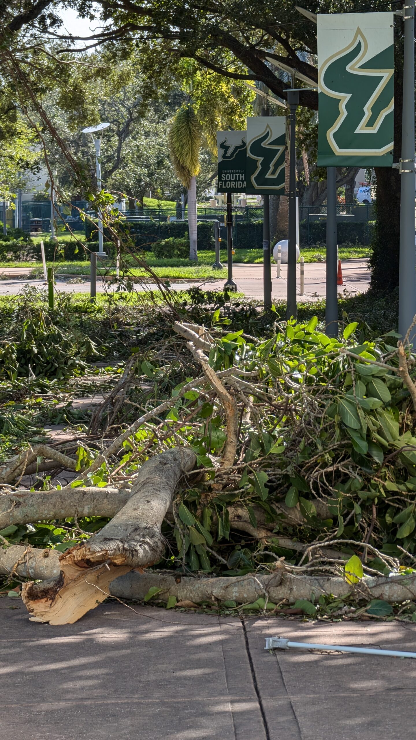
The USF St. Petersburg campus in the aftermath of Hurricane Milton in 2024.
Photo by Eddie Allen | The Crow’s Nest
By Jasmin Parrado
Almost a year after Hurricane Helene and Milton made landfall, meteorologists and researchers are aiming to identify and debunk the misperceptions that have endangered Americans in hurricane-prone states in the past.
The brief period of consecutive weather phenomena resulted in extensive damage still seen today across the Tampa Bay area. From Helene and Milton combined, there were over 260 reported fatalities and an estimated $100 billion in damages total.
Citizens were advised to mark their bodies to identify themselves in the case that search-and-rescue teams would have to turn toward recovery initiatives.
Meanwhile, social media platforms circulated a substantial amount of content depicting storm surges and rainwater flooding that reached further inland, destroying long-standing community infrastructures in its wake.
However, before the two storms made landfall just two weeks apart, that picture was largely unforeseen by Floridians.
The loss of urgency
Almost two decades after historically immense hurricanes like Katrina in 2005, wariness of hurricanes began faltering. With the increasing presence of social media and a dial-back on television meteorology, a different sentiment for hurricane season became the norm for Florida residents.
“Prior to last year, there was this apathy,” said Denis Phillips, television meteorologist for ABC Action News. “It had been over 100 years since a major hurricane hit the [Tampa] Bay area, and the reality is, we haven’t had a storm surge like [Helene], pretty much ever.”
The last hurricane recorded to directly hit the Tampa Bay area was a Category 3 storm in 1921, with a recorded storm surge of 11 feet and winds of up to 120 mph. Though Hurricane Ian was slated to break the region’s ensuing century-long streak of evasion in September 2022, it veered south last minute.
“I think what happened with Helene is, Floridians typically kind of get a feel for how things are, just from their experience in living here year in and year out; having near misses but never a direct hit,” Phillips said.
So, when Helene was projected to remain 100 miles offshore from the Bay area throughout its trajectory, residents didn’t particularly have any new concerns.
Cassandra O’Connor, a doctoral geography student and researcher at the University of South Florida, also noticed the public’s mixed response to what was a largely unprecedented anticipation of impact.
“Thankfully, it didn’t make landfall directly in Tampa, but there was that sentiment of not knowing what could happen if it hit Tampa. Because 100 years ago versus now, the infrastructure was completely different,” O’Connor said. “I think now there’s a wake-up call with what has previously occurred.”
What didn’t help was the proliferation of state identity archetypes on social media, where users either coped with or dismissed what appeared to be another regular storm season by throwing “hurricane parties,” venturing out into preceding tropical storm weather conditions and downplaying early evacuation warnings.
Phillips believes that a big contributor to an increasingly desensitized Floridian populace was the transition of weather-related news to social media. This led to more misinformation, and subsequently, more distrust of meteorology overall.
“It’s the whole ‘Chicken Little’ syndrome,” Phillips said. “Somebody posts something over and over again that the sky is falling and it’s not, until finally the sky is falling and no one’s going to believe that. They’re going to think it’s just another one of those examples of posting something that’s inaccurate.”
O’Connor is working alongside other students and USF geoscience professor Jennifer Collins on a survey of residents impacted last year and what led to them choosing to evacuate or stay.
The study, backed by USF’s partnership with other universities beyond the state, will focus on the information people have worked with in their decision-making prior to landfall. This includes weather models, such as the Saffir-Simpson hurricane wind scale, and general risk perceptions that the public might use to determine how severe a storm can appear to communities.
O’Connor feels that last season’s danger was the brief timeframe between the storms, which offered little reprieve regardless of any post-storm awareness communities might have experienced.
“There were a lot of people that maybe were a little bit weary on Helene and not really doing as much,” O’Connor said. “But when Milton came around and they were realizing what had happened, the close proximity and time of the hurricanes potentially could’ve influenced how people made decisions.”
With the arrival of this year’s Atlantic hurricane season on June 1, Florida residents now reportedly approach the topic with significantly more anxiety, especially in light of rising political conversations of climate change that still are perceived as a non-issue or simply a regular fluctuation of climate activity.
Additionally, residents are responding with a higher incentive to prepare for this season. Phillips advises against looking to unknown social media sources for information this time around.
“You choose your sources wisely. You choose a source that’s reputable, you choose the one that you know… Because there are so many fly-by-night armchair meteorologists,” Phillips said. “And it’s very clear people are getting their information on social media. You can’t ignore that. That is the new reality.”
Where danger lies
When enduring Milton and Helene, Florida experienced all three major tropical cyclone phenomena, Phillips said.
Helene’s force brought in a deadly storm surge, while Milton’s additional winds and torrential rainfall led to flash floods that accumulated just as much water as the former storm.
“Storm surge has nothing to do with rainfall. It’s literally a storm pushing the water along the coastal areas,” Phillips explained. “The thing to remember is, if you live along the coast, you’re more than likely going to be dealing with storm surge, whereas flooding from rainfall can happen anywhere.”
Phillips also noted that wind directions can indicate where water will likely move in accordance with a storm — another factor to look out for.
“In dealing with surge, wherever landfall occurs, just to the south is where the worst of the surge will be,” he said. “Off to the north, you’ll have less or zero surge, or even what we call a reverse surge, where the water is actually pushed out, like what happened with Irma.”
Inaccurate models and Impact Predictions
Another aspect of storm preparation that might have affected the public’s view of the last hurricane season is an issue that has long frustrated meteorologists, Phillips recalls.
Certain storm prediction models generate forecasts that extend beyond the traditional seven-day outlook on weather; the Global Forecast System (GFS) is one of them.
The GFS model accounts for variable measurements like wind, soil moisture and precipitation to determine weather conditions and trajectories. Its accuracy declines rapidly beyond the seven-day range, but media sources often look to it for predictions, and two-week forecasts easily circulate around the internet.
Last year, the GFS predicted 462 named tropical storms — and only 18 occurred.
“What concerns me is, you get people who are posting these model runs over and over again, and once every blue moon it’s going to be right,” Phillips said. “But the majority of the time, if you do the math —18 storms out of 462 — that’s less than 4 percent accurate.”
Phillips affirms that it is best to refer to a forecast that remains in range.
“The reality of it is, if you see a model that is seven days out or less, there’s at least a reasonable chance that it’s going to be accurate. Anything more than seven days is fantasy land,” he said.
As for other models, O’Connor recalls that previous studies have shown how residents make assumptions about impact and danger solely based off visuals such as the forecast cone. Viewers often assess the boundaries of the cone and assume that there won’t be any impacts outside it, she said.
“People also tend to make evacuation decisions based on the Saffir Simpson Wind Scale, which basically looks at just the wind speed of the hurricane,” O’Connor said. “However, wind speed isn’t the only story when it comes to a hurricane.”
Floridians who based their decisions solely on the bounds of the storm or its wind damage would soon learn they were in more danger than they anticipated.
Helene’s trajectory as a Category 4 tropical cyclone at landfall infiltrated the Big Bend area and extended inland, with enough strength to affect the Carolinas and the South Appalachians. The storm’s winds were devastatingly strong.
But Florida’s most immense damage came from water.
“The expression that I use is, ‘Hide from the wind, run from the water.’ I think Helene was a perfect example of that,” Phillips said.
Communities had to navigate record highs of the resulting storm surge, despite the cyclone’s distance and phases along the cone track. Tampa General Hospital’s Aqua Fence was able to protect its building, but not without battling a 7-foot waterfront.
“I think it was a learning experience for people in our area, that you don’t have to have a direct hit to have massive impacts,” Phillips said. “I really would expect from this point on, that when people hear that there’s a surge of 6-to-8-foot forecast, they now kind of have a benchmark.”