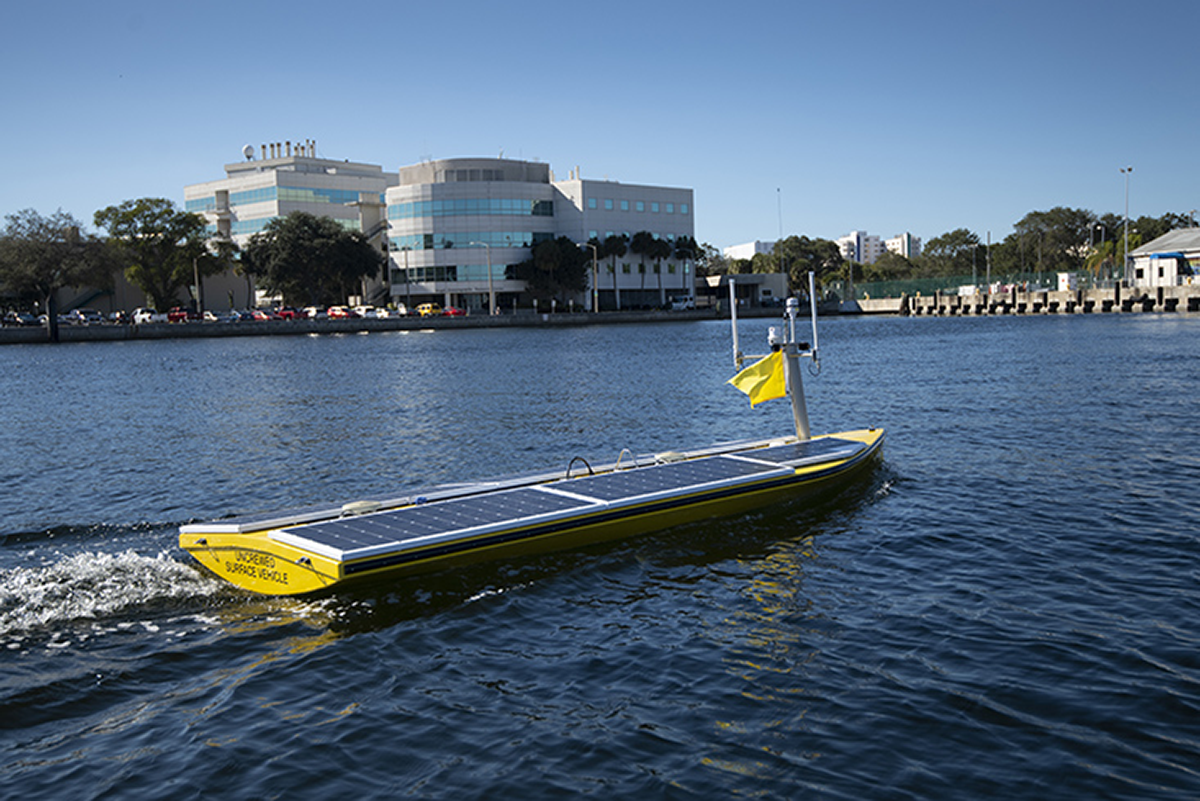
Pictured above: SeaTracs’ USV travels at about 4 knots as it surveys the coastal topography of the Tampa Bay area.
Courtesy of USF
By Brianna Madden
The University of South Florida’s College of Marine Science (CMS) recently launched an uncrewed solar powered vessel to map Tampa Bay’s coastal areas.
With the support from the National Oceanic and Atmospheric Association (NOAA) and other private companies, such as SeaTrac and Fugro, researchers hope to gain a better understanding of how to protect the delicate coastlines of Tampa Bay.
The technology used in this mission is revolutionary and scientists hope that the results will inspire similar projects around the globe.
SeaTrac has designed and constructed an Uncrewed Surface Vessel (USV) to map specific target areas near Egmont Key, John’s Pass, and the St. Petersburg Bay Reef.
The sixteen-foot long USV is equipped with revolutionary acoustic sensors and sonar. This technology is capable of producing high resolution images of the seafloor and sending them directly to awaiting scientists.
Powered by solar panels and remotely controlled without an on-board crew, the USV is a sustainable way to conduct research.
A “chase boat” will closely follow the USV to ensure its safety throughout the mission. This includes looking out for other vessels and marine animals.
Researchers are also using satellite imagery to assist in filling in the blanks the USV might miss.
The satellite is capable of mapping a larger area of Tampa Bay since the USV is limited to traveling at about 3-4 knots (3.5 mph). However, compared to the USV, the satellite produces less detailed images of the complex and ever-changing coastal areas of Tampa Bay.
In addition to SeaTrac’s contribution, Fugro produced a Rapid Airborne Multibeam Mapping System (RAMMS). Starting Jan. of 2022, an airplane containing the RAMMS technology will survey 90 square miles of Tampa Bay to offer further information on geographical features.
This project is essential to devising a plan to protect Florida’s valuable coastal areas.

The Florida peninsula is characterized as a landmass at surface level with minimal elevation. Therefore, coastlines are Florida’s main defense against floods, storms and sea level rise due to global warming.
Researchers are hoping to discover more about the relationship between humans and the ocean, how to maintain a healthy environment and to encourage future researchers to see the importance of mapping coastal topography.
Coastal areas have proved to be the most difficult regions to survey since water clarity, visibility, and depth varies along the entire coastline. However, they are the most vulnerable to weather, pollution and effects of global warming, making it imperative to map and analyze.
Scientists hope to exhibit cost efficient surveying to learn more about coastal innovation, natural resources, mining, storm surge modeling, maritime safety and fisheries management.
Protecting the Florida coastlines is becoming a number one priority for USF, CMS, NOAA and other organizations as sea level rises and storm events continue to break down the primary defense of low-lying land.
The goal of this mission is not only to better protect our vulnerable coastlines, but to experiment with different technology to devise the most successful combination of survey techniques.
The project is considered a breakthrough for USF researchers, as well as the marine science community, especially those that specialize in seafloor topography.
Due to its potential, this mission has been highly supported through financial needs, technology and strong voices.
“New technology approaches can improve priorities such as shallow water mapping, coastal resilience and emergency response,” said Neil Watson, chief scientist at NOAA’s Office of Coastal Survey.
While the technological advances already achieved are revolutionary, researchers are confident that the USV will yield successful results.
“We’re excited to find the best mix of technologies for surveying complex, shallow areas – a top priority for Florida, the nation, and the globe,” said Steve Murawski of the Center for Ocean Mapping and Innovative Technologies.
Unfortunately, more of Mars has been mapped than Earth’s oceans, leaving about 50% of what scientists call the Exclusive Economic Zone (EEZ) uncharted.
“I’m delighted to see USF and its partners answering the call for research and innovation in coastal mapping” said Florida House Speaker Chris Sprowls.
This innovative step towards technological advancement intends to offer endless opportunities to better protect and understand the crucial waterways of not only Tampa Bay, but the entire globe.